In order to generate carbon credits through the reduction of deforestation and forest degradation in the state’s territory, it is necessary to quantify the reduction in greenhouse gas emissions resulting from the REDD+ actions implemented. This quantification occurs through a comparison of the current scenario (the current level of deforestation and forest degradation is measured).
With a past reference scenario (a previous period is considered to establish a historical pattern or trend of deforestation and degradation). The difference between these two scenarios indicates the amount of emissions avoided, that is, how much less carbon was released into the atmosphere compared to the past.
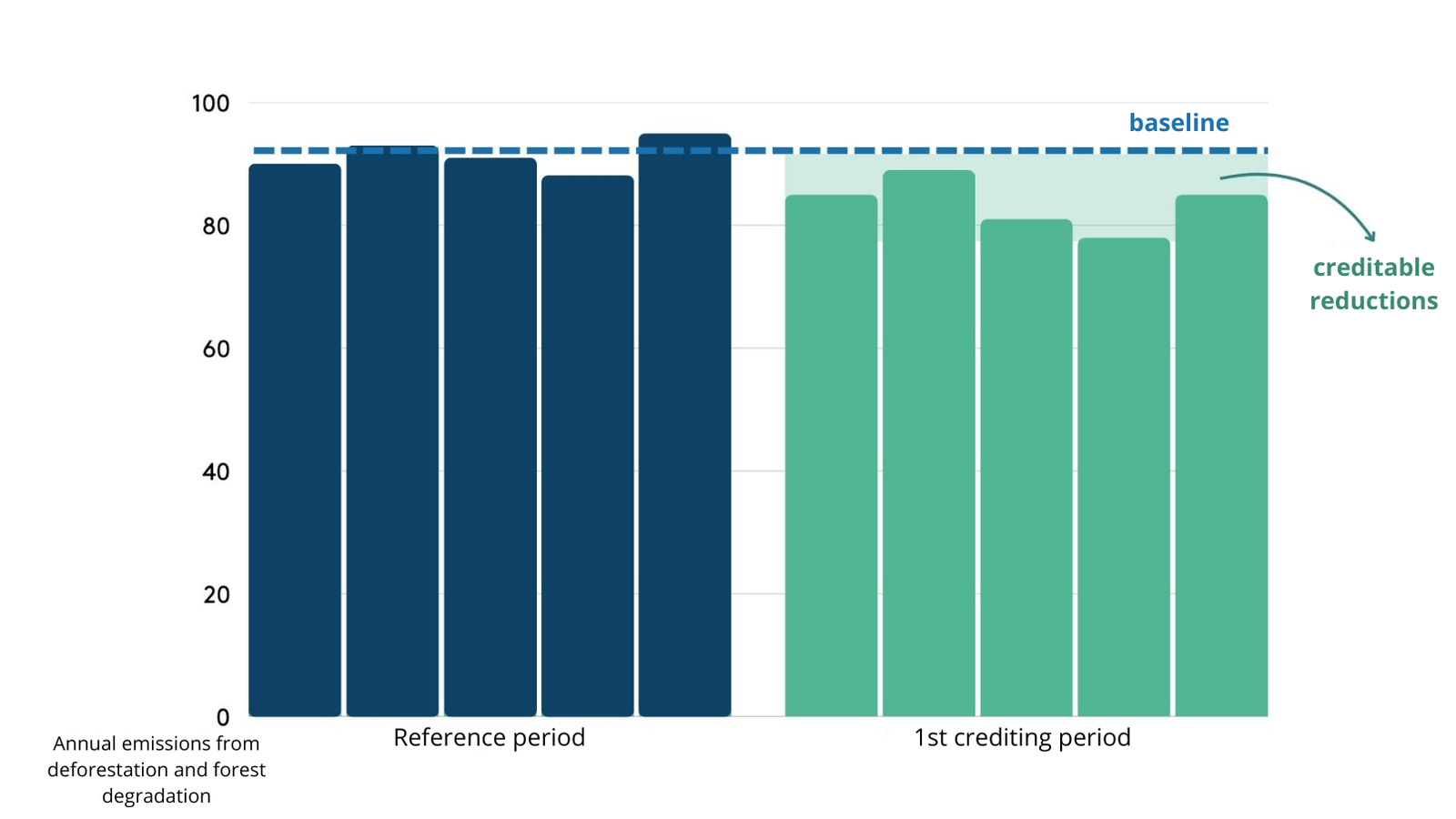
Reference period (past):
A time interval within the past five years (in the case of JREDD+ Tocantins) used as a basis for evaluating the historical behavior of deforestation in the state. This period is used to calculate an average of emissions caused by deforestation, helping to establish a baseline that will allow comparison with future years.
Reference level or baseline:
This is the average of annual forest carbon emissions calculated during the reference period. This average represents what would be emitted if deforestation continues at the same historical rate. If emissions in the crediting period are lower than this baseline, the difference can be converted into carbon credits.
Emissions Reduction:
Occurs when the annual emissions rate in the crediting period is below the average established by the baseline calculated in the reference period. This indicates that there was less deforestation and forest degradation and, consequently, less carbon released into the atmosphere. This difference between expected emissions (based on the past baseline) and current emissions (in the crediting period) represents the amount of carbon that was avoided and can be converted into carbon credits.
Crediting period:
This is the time interval (also five years in the case of JREDD+ Tocantins) during which carbon credits will be generated. During this period, annual emissions from deforestation and degradation will be monitored and compared with the baseline to determine whether there has been an effective reduction.
In summary, the reference period establishes a point of comparison, the baseline quantifies the average emissions for that period, and the crediting period is when reductions are measured and converted into carbon credits, if there is success in mitigating deforestation and forest degradation.
The Tocantins Jurisdictional REDD+ Program is in the process of generating jurisdictional carbon credits for its first crediting period (2020 to 2024), using the baseline calculated in the reference period from 2015 to 2019.
In order to quantify the reductions in forest carbon emissions in its territory, the State must monitor deforestation and forest degradation. This is done through a Monitoring, Reporting and Verification (MRV) system.
The MRV calculations of the Jurisdictional Program of the State of Tocantins consist of the quantification of four components: (1) emissions from deforestation in the Amazon biome; (2) emissions from deforestation in the Cerrado biome; (3) emissions from degradation in the Amazon biome; and (4) emissions from degradation in the Cerrado biome.
To calculate components (1), (2) and (3), the State has used official sources of data on deforestation and degradation used by Brazil’s reference level or baseline, periodically submitted by the country to the United Nations Framework Convention on Climate Change (UNFCCC). The calculation of component (4), however, is not yet performed by the federal government in its periodic reports. For this reason, in calculating its emissions from forest degradation by fire in the Cerrado biome, the State used the MapBiomas database and employed a methodology developed by the Amazon Environmental Research Institute (IPAM).
Emission reductions for the period 2020-2023 have already been quantified by the State. However, adjustments requested by the ART or the verification entity may be necessary to ensure that the calculations comply with the TREES Standard. The calculations will be published on this page as soon as they are available.